Atmospheric Motion Vectors (AMV)
Atmospheric motion over a wide area can be derived by tracing the movement of individual cloud or water vapor patterns in successive satellite images. The resulting data product is called Atmospheric Motion Vectors (AMV) , and includes information on wind speed and direction. AMVs are useful for numerical weather prediction, especially over ocean areas where other wind observations are very sparse.
AMVs are produced with cloud feature-tracking and cloud height estimation algorithm based on imagery from visible, infrared and water vapor bands for the Himawari coverage region. They are derived every hour and provided to National Meteorological and Hydrological Services (NMHSs) in Binary Universal Form for data Representation (BUFR) format.
Reference
Meteorological Satellite Center Technical Note No.64
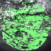
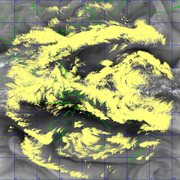
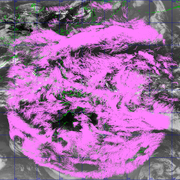
Sample
Sample images below are AMV at 03 UTC on June 14 2015.
Real-time data distribution
AMVs are distributed via the Global Telecommunication System (GTS) exclusively for National Meteorological and Hydrological Services (NMHSs).