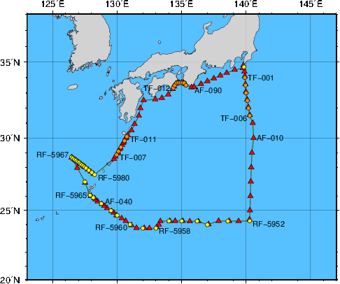
Station Chart
| ● | Stations for hydrographic observation | Station Number: RF-xxxx |
| ◆ | Stations for XCTD observation | Station Number: RF-xxxx |
| ▲ | Stations for subsurface current observation | Station Number: AF-xxx |
| ● | Stations for XBT-DBT observation | Station Number: TF-xxx |
Area: South of Honshu and the East China Sea
Period: 07 January 2017 - 26 January 2017
| Data | File name | File type | File size | Last updated |
|---|---|---|---|---|
| Cruise Information | ||||
| Summary of cruise | RF1701.SUM | TXT | 19 kB | 30 November 2017 |
| Station information | RF1701.STN | TXT | 44 kB | 8 May 2017 |
| Oceanographic Data | ||||
| Hydrographic data | RF1701.E | TXT | 100 kB | 30 January 2026 |
| CTD and XCTD data | RF1701.CTD.ZIP | ZIP | 534 kB | 12 July 2017 |
| XBT-DBT data for standerd depth | RF1701.T | TXT | 4 kB | 28 June 2017 |
| XBT-DBT data | RF1701.BT.ZIP | ZIP | 45 kB | 12 July 2017 |
| Water sample data | RF1701.WAT.ZIP | ZIP | 42 kB | 27 February 2026 |
| Subsurface current data | RF1701.A | TXT | 24 kB | 28 June 2017 |
| Greenhouse gas data | RF1701.WAY | TXT | 41 kB | 3 October 2018 |
| Petroleum hydrocarbon and heavy metal data | RF1701.OHM | TXT | 1 kB | 4 April 2018 |
| Floating pollutant data | RF1701.FLT | TXT | 1 kB | 4 April 2018 |
| Marine Meteorological Data | ||||
| Maritime meteorological data | JGQH2017IM5.TXT | TXT | 256 kB | 2 April 2018 |
| Aerological data | RF1701.AER.ZIP | ZIP | 14 kB | 12 July 2017 |