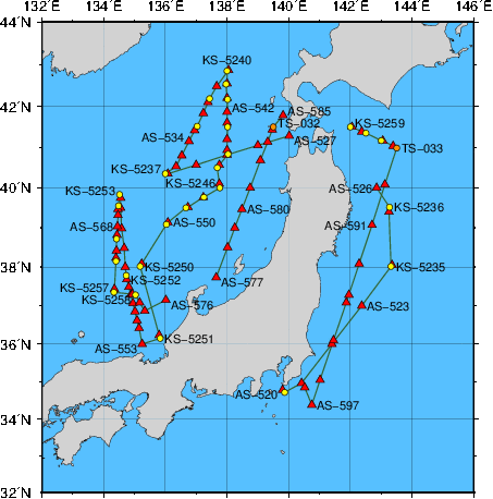
Station Chart
| ● | Stations for hydrographic observation | Station Number: KS-xxxx |
| ◆ | Stations for XCTD observation | Station Number: KS-xxxx |
| ▲ | Stations for subsurface current observation | Station Number: AS-xxx |
| ● | Stations for XBT-DBT observation | Station Number: TS-xxx |
Area: East of Honshu and the Sea of Japan
Period: 07 November 2017 - 08 December 2017
| Data | File name | File type | File size | Last updated |
|---|---|---|---|---|
| Cruise Information | ||||
| Summary of cruise | KS1708.SUM | TXT | 20 kB | 8 February 2019 |
| Station information | KS1708.STN | TXT | 35 kB | 23 March 2018 |
| Oceanographic Data | ||||
| Hydrographic data | KS1708.E | TXT | 113 kB | 30 January 2026 |
| CTD and XCTD data | KS1708.CTD.ZIP | ZIP | 636 kB | 2 April 2018 |
| XBT-DBT data for standerd depth | KS1708.T | TXT | 1 kB | 2 April 2018 |
| XBT-DBT data | KS1708.BT.ZIP | ZIP | 7 kB | 2 April 2018 |
| Water sample data | KS1708.WAT.ZIP | ZIP | 42 kB | 27 February 2026 |
| Subsurface current data | KS1708.A | TXT | 21 kB | 2 April 2018 |
| Greenhouse gas data | KS1708.WAY | TXT | 45 kB | 3 October 2018 |
| Petroleum hydrocarbon and heavy metal data | KS1708.OHM | TXT | 1 kB | 4 April 2018 |
| Floating pollutant data | KS1708.FLT | TXT | 1 kB | 4 April 2018 |
| Marine Meteorological Data | ||||
| Maritime meteorological data | JPBN2017IM5.TXT | TXT | 237 kB | 2 April 2018 |