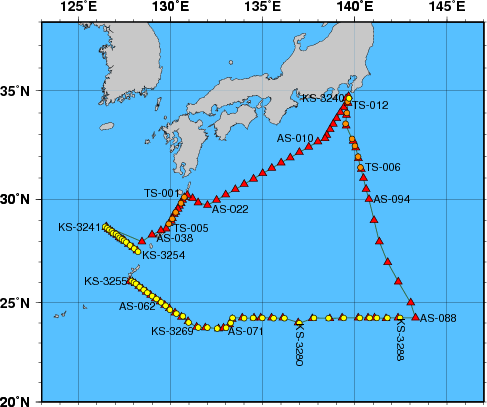
Station Chart
| ● | Stations for hydrographic observation | Station Number: KS-xxxx |
| ◆ | Stations for XCTD observation | Station Number: KS-xxxx |
| ▲ | Stations for subsurface current observation | Station Number: AS-xxx |
| ● | Stations for XBT-DBT observation | Station Number: TS-xxx |
Area: The western North Pacific and the East China Sea
Period: 08 January 2012 - 26 January 2012
| Data | File name | File type | File size | Last updated |
|---|---|---|---|---|
| Cruise Information | ||||
| Summary of cruise | KS1201.SUM | TXT | 16 kB | 14 February 2017 |
| Station information | KS1201.STN | TXT | 56 kB | 23 December 2014 |
| Oceanographic Data | ||||
| Hydrographic data | KS1201.E | TXT | 162 kB | 28 December 2016 |
| CTD and XCTD data | KS1201.CTD.ZIP | ZIP | 913 kB | 16 April 2014 |
| XBT-DBT data for standerd depth | KS1201.T | TXT | 3 kB | 21 June 2012 |
| XBT-DBT data | KS1201.BT.ZIP | ZIP | 35 kB | 21 June 2012 |
| Water sample data | KS1201.WAT.ZIP | ZIP | 45 kB | 28 December 2016 |
| Subsurface current data | KS1201.A | TXT | 27 kB | 21 June 2012 |
| Greenhouse gas data | KS1201.WAY | TXT | 41 kB | 24 May 2013 |
| Petroleum hydrocarbon and heavy metal data | KS1201.OHM | TXT | 1 kB | 19 February 2016 |
| Floating pollutant data | KS1201.FLT | TXT | 1 kB | 5 April 2013 |
| Marine Meteorological Data | ||||
| Maritime meteorological data | JPBN2012IM5.TXT | TXT | 231 kB | 18 July 2013 |