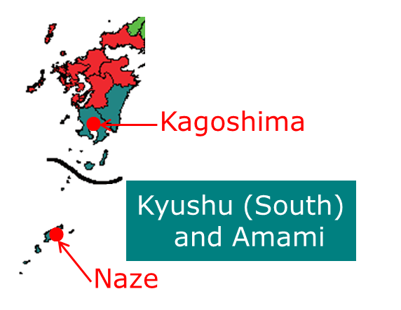
Figure 1 Location of Kagoshima City and Amami City Naze
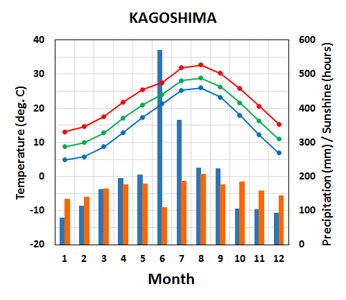
Figure 2 Seasonal variation of meteorological elements in Kagoshima City The green, red and blue lines indicate monthly averages of daily mean, maximum and minimum temperatures, respectively. The blue and brown bars show monthly precipitation amounts and monthly sunshine durations, respectively.
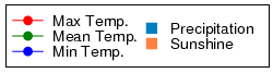
Figure 3 Same as Figure 2 but for Amami City Naze Winter (December-January-February)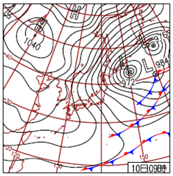
Figure 4 Weather chart at 00UTC, 10 December 2012 In winter (December-January-February), the Siberian High develops over the Eurasian Continent and the Aleutian Low develops over the northern North Pacific. Prevailing northwesterly winds cause the advection of cold air from Siberia to Kyushu (South) and Amami. The northwesterly winds also bring sunny conditions to Kyushu (South) and cloudy or rainy conditions to Amami. Amami has mild winters due to its location in a subtropical area. Spring (March-April-May)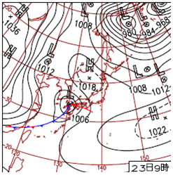
Figure 5 Weather chart for 00UTC on 23 March 2012 In spring (March-April-May), migratory cyclones and anticyclones that alternately move eastward prevail across Japan. Temperature increases (decreases) in front (back) of cyclonic systems due to warm southerly (cold northerly) flow. Temperature in Kyushu (South) and Amami rises gradually with large short-term variations. The sunshine duration is long in the second half of spring in Kyushu (South) due to the predominance of anticyclonic systems. The rainy season, known as the Baiu, begins in the middle of May in Amami. Summer (June-July-August)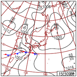
Figure 6 Weather chart for 00UTC on 15 June 2012 Precipitation in the Baiu is caused by a stationary front, called the Baiu front, which forms where a warm maritime tropical air mass meets a cool polar maritime air mass. The Baiu begins in late May and ends in the middle of July in Kyushu (South), while it begins in the middle of May and ends in late June in Amami. These districts have Japan's heaviest rainfall totals. In the second half of summer, the North Pacific High extends northwestward around Japan, bringing very hot, humid, and sunny conditions, sometimes accompanied by temperatures of 35°C or above, to Kyushu (South). Amami rarely experiences temperatures of 35°C or above because it has an oceanic climate. Autumn (September-October-November)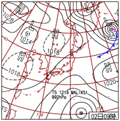
Figure 7 Weather chart for 00UTC on 2 October 2012 In autumn (September-October-November), temperatures fall gradually. The autumnal rain front and tropical cyclones affect autumn weather. In October, the frequent passage of anticyclonic systems brings sunny conditions and refreshing air to Kyushu (South), while more cloudy or rainy conditions with southward cold flow tend to be observed in Amami. |